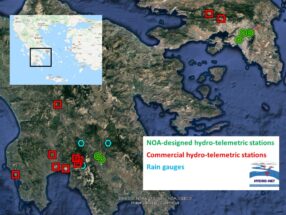
HYDRONET is a pilot streamflow monitoring network established and operated by the Institute for Environmental Research and Sustainable Development of the National Observatory of Athens (NOA) within the “HYDRONET” project (2018–2021) Hydro-Telemetric Network of Surface Waters: Gauging instruments, smart technologies, installation and operation. HYDRONET aspires to establish time series of high-quality data for water resources management and for risk assessment of hydrological extremes, as well as for water-use planning and hydraulic infrastructures design. Sixteen stations are currently in operation (ten commercial and six designed and constructed by NOA), six in Attica, seven in the Western Peloponnese and three in Eastern Peloponnese water districts.
The selection of basins has been prioritized based on relevant socio-economic and environmental assets and land use (inter alia, the safety of the population in flood-prone areas).
Criteria considered in designing HYDRONET, to ensure its economically viable, long-term operation, included also the available financial resources, the stations’ proximity to NOA (for reduced travel time and costs) and their deployment in geographically adjacent areas (for efficient field campaigns and station maintenance).
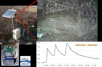
Hydraulic suitability criteria were applied in the selection of monitoring sites and safety of equipment has been ascertained, as much as possible. Measurements of the water stage are taken every 10 min and the data are sent to NOA’s HYDRONET server for automatic processing (quality control) and storage and then forwarded to the platform https://openhi.net/.

Technological achievement: Development of an Inexpensive Hydro-Telemetric Station
To reduce expenditures for hydrometric equipment, a prototype hydro-telemetry system was designed and constructed. That system combines custom-built firmware and intelligent sensing technologies with telecommunication at low cost, about 50% of the price of a comparable commercial station. This prototype, is equipped with an ultrasonic sensor for measuring stage, an air thermometer, a GPRS modem, a camera and a data logger (it can also receive input from a rain gauge) and is powered by a solar panel; data and photos are transmitted to NOA’s server via mobile internet. The system’s additional advantages are flexibility in programming, low maintenance cost, and the ability to extend its capabilities with additional sensors (e.g., it is already compatible with water quality sensors and a video camera). Six stations have been produced and have been installed at stream-sites in Attica and in Evrotas Laconia.

Scientific advancements: Discharge Estimation in Open Channels from Surface Velocity Measurements
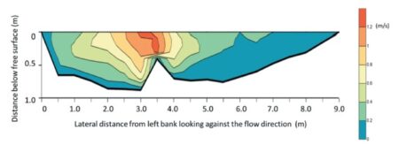
The discharge through a cross-section of a stream is estimated indirectly for operational purposes, by converting observed stages h to flows Q via rating curves Q(h). Rating curves at monitoring stations are established, in principle, by measuring and integrating the velocity field over a cross-section of known bathymetry for a range of flows. However, there are practical issues involved. Point-sampling of the velocity field with a current meter is tedious and often dangerous (prohibitive in high flows).
We developed a maximum-entropy method for streamflow estimation from surface velocities. Tests at cross-sections of streams, with known variable bathymetry and roughness, demonstrate the method’s ability to estimate the discharge solely from surface-velocity observations, with ± 5% accuracy referenced to discharge determined from densely sampled in-stream velocities (Koussis et al., 2022).

Hydrometry
Standard practice for estimating the discharge at a channel cross-section of known bathymetry is point-sampling of the velocity field with a current meter. The selection of sampling points is guided by the Prandtl-von Kármán logarithmic profile of uniform turbulent flow in an infinitely wide channel, at 60% of a shallow (≤ 0.76 m) depth below the free surface, or at 20% and 80%, or at 20%, 60% and 80% of depth, and the observations on a midsection are weighted appropriately to obtain the mean velocity (World Meteorological Organization 2010). The HYDRO-NET team, performs field studies and current meter measurements at the stations’ locations, in order to produce rating curves.


