


HYDRONET Hydro-Telemetry Stations Network
The devastating floods in Thessaly in 2020 and 2023 once again highlighted the importance of monitoring the country’s surface water systems. The HYDRONET of NOA (https://hydronet.noa.gr) was established in 2018 within the framework of the HIMIOFOTS Project (OPS 5002739) and represents an evolution and expansion of previous hydro-telemetric networks operated by NOA (DEUCALION Networks – 2011 and TELEFLEUR – 1998). The HYDRONET hydro-telemetric stations measure the water level of representative – and civil protection-critical – watercourses and send the measurements to the NOA Hydronet server for automatic quality control and storage. Subsequently, the measurements can be made available via a web platform, allowing interested parties, for example, to monitor the fluctuation of a river’s level/discharge in real-time during a flood event. The collected data are essential for assessing water potential and flood/drought risks in the catchment area, especially during a period of climate change, which affects the design parameters of protection works.
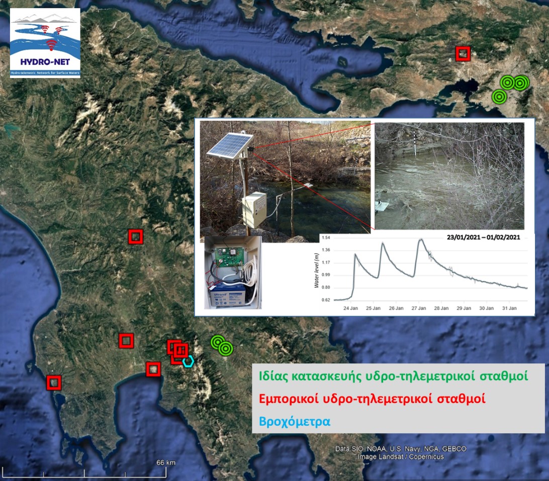
The HYDRONET network (https://doi.org/10.3390/hydrology10010019) consists of commercial and custom-built hydro-telemetric stations, piezometric stations, and rain gauges, while the HYDRONET system (stations – server – database – hydrometric measurements) provides a comprehensive framework for collecting, transmitting, handling, and utilizing data that combine technological originality and advanced scientific methods with efficient resource use.
The technological innovations of HYDRONET concern the design and construction of a prototype hydro-telemetry system that combines customized firmware and smart measurement technologies with low-cost telecommunications, approximately 50% of the price of a commercial station. The prototype is equipped with an ultrasonic sensor for water level measurement, a thermometer, a GPRS modem, a camera, and a memory card (it can also receive input from a rain gauge) and is powered by a battery charged by a photovoltaic panel. Data and photos are transmitted to the server via the internet.
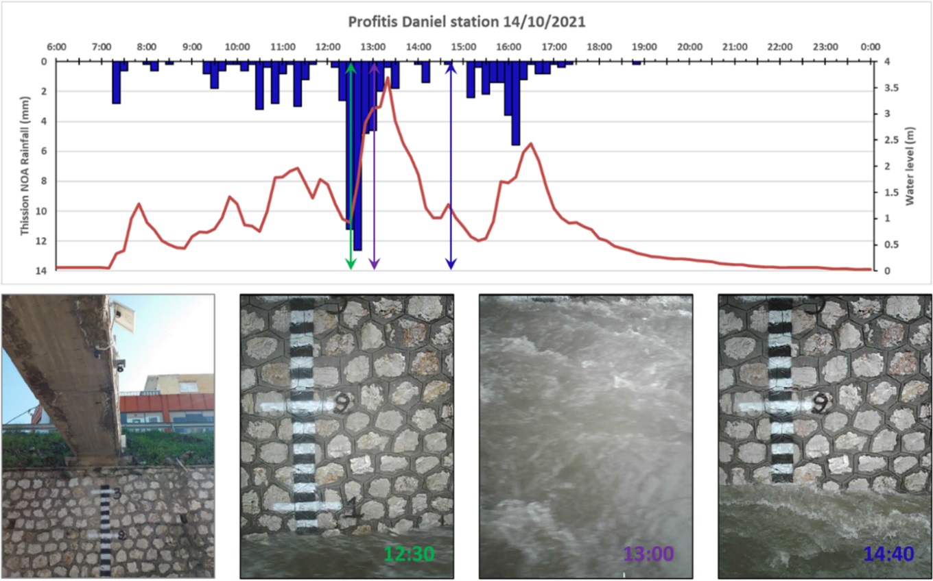
The additional advantages of these systems are programming flexibility, low maintenance costs, and the ability to expand monitoring capabilities with additional sensors (e.g., for water quality monitoring, video camera). Six pilot stations were built and installed in Attica and Laconia. The relevant diagram shows the rainfall from the NOA station in Thissio and the corresponding hydrograph from the prototype station of the Prophet Daniel stream (Renti, Athens) for October 14, 2021, as well as successive photos from the station’s automatic camera depicting the general conditions prevailing in the stream.
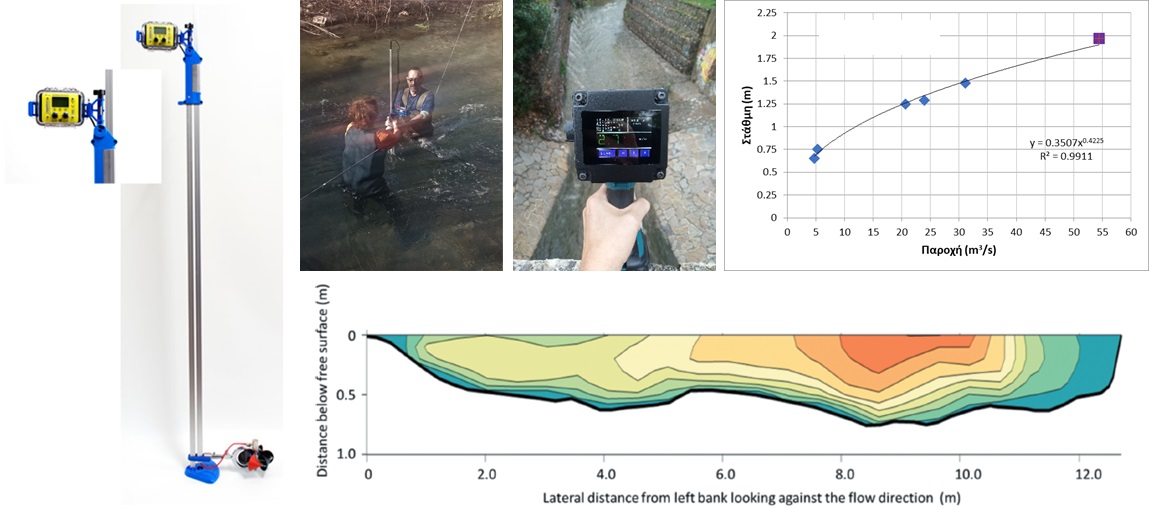
The scientific innovations concern the development of a combined method of hydrometric measurements and hydromechanical-hydraulic calculation for estimating stream discharge, based on the theory of maximum entropy. This method allows the estimation of stream discharge from the measurement of surface water velocity, thereby avoiding costly, time-consuming, and often impossible, due to danger, field velocity measurements with a current meter (https://doi.org/10.1080/02626667.2022.2030059).
Campaigns are organized at the station locations to perform flow velocity measurements with a current meter (portable instruments of two types: HYQUESTSOLUTIONS and Global Water) (classical hydrometry), and/or with a surface velocity radar (SVR, VIATRONICS), and/or with advanced optical methods for surface velocity measurement, in order to create stage-discharge curves for each location. During field operations, the standards and procedures of the World Meteorological Organization (WMO) are generally followed.
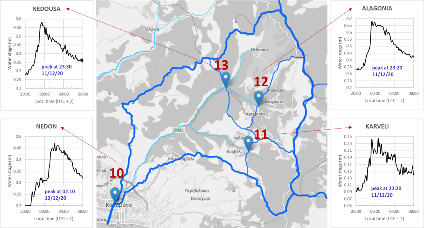
HYDRONET can be at the core of an early flood warning system, which is a valuable non-structural measure for protecting human life, infrastructure, and the local economy. A reliable flood warning system requires continuous monitoring of the main stream and its tributaries in a river basin and regular maintenance of the monitoring network. Schroeter et al. (2008) estimate that a relatively short warning time, on the order of a few hours, would significantly reduce damages. Even a one-hour warning time could offer a 20% reduction in damages, and this percentage increases to 60% for a 12-hour warning time. The figure shows the Nedontas river basin in Messenia and the hydrographs at the tributary stations and at the Nedontas station near the city center of Kalamata for the flood on December 11, 2020. The time lags between the peaks provide approximately 3 hours of warning time, but, considering the rate of water level rise as a flood precursor, the time doubles to ~6 hours.