


SERVICES
IERSD offers high-quality services in the fields of environmental protection and sustainable development by developing and implementing reliable quantitative and qualitative methodologies, utilizing high-quality infrastructure and equipment, and providing data and results that fully meet the needs of end-users, as well as technical support from specialized personnel.

Laboratory Analyses of Atmospheric Samples
Specialized laboratory chemical analyses of atmospheric samples at the IERSD Atmospheric Chemistry Laboratory for the determination of suspended particulate matter concentration and various targeted chemical compounds, using a variety of analytical instruments for chromatographic and spectroscopic applications.
Air Quality Monitoring
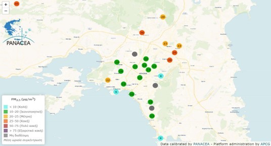
Real-time measurement data of PM2.5 concentration from the sensors of the YPATIA operational unit (part of the PANACEA national research infrastructure network) in the atmosphere of Athens and other areas. Also, measurement data for NOx and O3 from automatic stations in Attica, and for specialized gaseous and particulate pollutants from the Urban Background Air Pollution Monitoring Superstation in Thissio. Additionally, measurement data for main gaseous and particulate pollutants from the Mobile Air Pollution & Noise Monitoring Station of IERSD/NOA.
Anthropogenic Emissions – Pollution Forecasting
Historical data (hourly and monthly values) of gaseous and particulate pollutant emissions (CO, NH3, NOx, NMVOCs, PM10, PM2.5, heavy metals, PAHs), as well as greenhouse gases in map format for the entire territory (6×6 km2) and from all anthropogenic activities (FEI-GREGAA database). Daily air quality forecast according to the European AQI index for cities and points of interest to inform the public.

Noise and Vibration Assessment
Noise and vibration measurements with appropriate equipment that meets international and national specifications, environmental noise assessment and mapping, as well as the preparation of Action Plans, in accordance with the requirements of Directive 2022/49/EC and using appropriate models and methodologies.
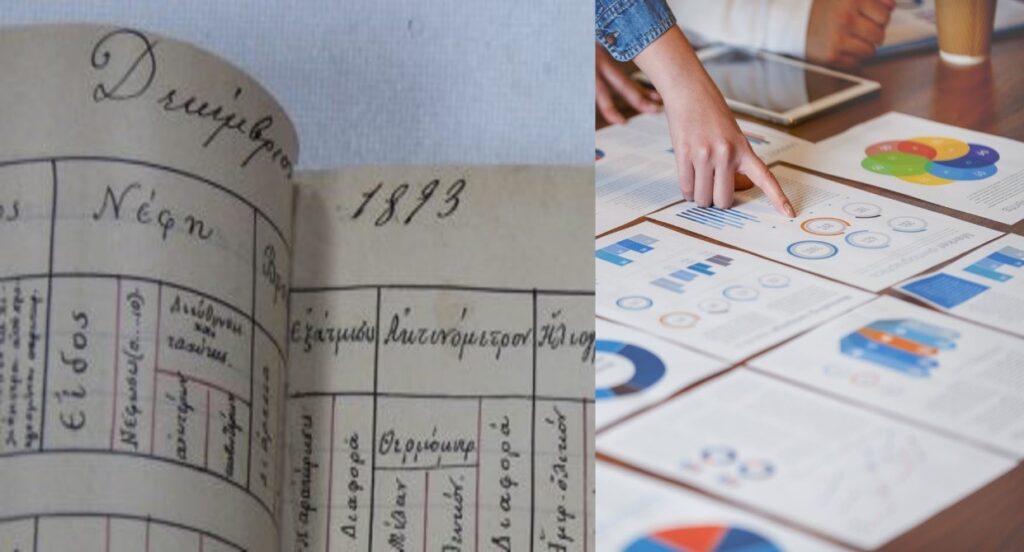
Historical Climate Time Series of Athens
Climate data spanning more than 150 years, derived from measurements and observations in the Athens area, for all basic meteorological parameters. This archive constitutes the oldest and most complete historical climate information database in Greece.
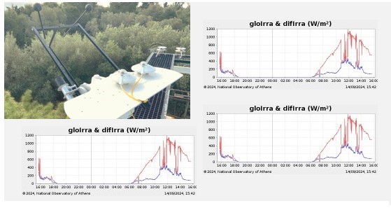
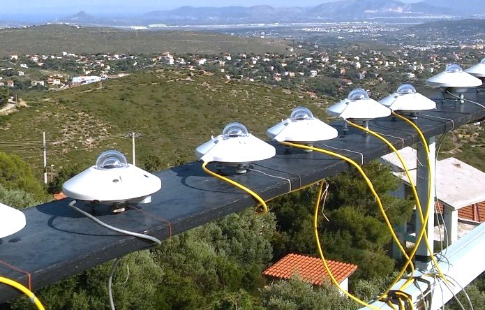
Radiometric Observation Data
Real-time data (updated every 10 minutes) from high-resolution measurements (every 1 minute) of the automatic radiometric stations of IERSD’s nationwide network, which record the intensity of incoming solar radiation (total and/or its components) received at ground level, along with all basic meteorological parameters.
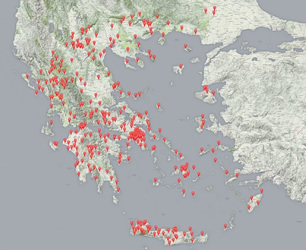
Provision of Meteorological Data – Meteosearch
Provision of data from the entire network of METEO unit’s automatic meteorological stations on a daily step. Provision of data at a smaller time step, upon request.
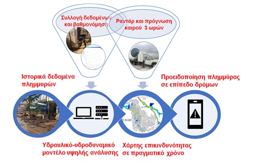
Short-term Forecasting of Intense Rainfall and Flood Phenomena
Provision of short-term rainfall forecasts (3 hours) at high spatial resolution with assimilation of mobile meteorological radar data into a prognostic meteorological model. Provision of specialized forecasts of flood impacts, mainly in urban areas. Possibility of installing and operating a mobile meteorological radar in areas of interest and providing relevant data, measurement maps, and forecasts (up to 3 hours) of rainfall and flood risk (water depth and velocity) in real time.
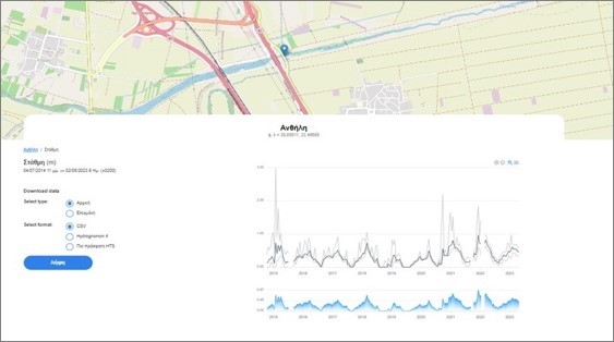
Hydrological Data – Hydro-telemetric Services for Watercourses
Near real-time level data and time series of level data from the installed hydro-telemetric stations of the HYDRONET network in rivers/streams in Attica and Peloponnese, which are essential for water resource management, risk assessment of extreme hydrological phenomena (floods and droughts), as well as for the design of hydraulic works.
Meteorological Instrument Calibration
Specialized calibrations/verifications of meteorological sensors (thermometers, hygrometers, barometers, rain gauges, etc.) and radiometers (thermopile or PV cell pyranometers of various types) on behalf of both public bodies and private companies, following relevant international standards, as well as providing technical support and consulting services to third parties for the selection and installation of meteorological and radiometric equipment.
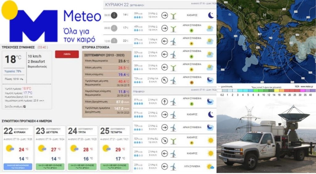
Weather Forecasting and Observation – Meteo.gr
Operational 6-day weather forecast for more than 500 cities across Greece, as well as detailed wind and wave forecasts for the Greek seas. Weather and swimming conditions forecasts for 700 Greek beaches, weather forecasts for the entire Greek road network, and desert dust transport forecasts. Display of measurements from the METEO unit’s automatic meteorological station network on maps, tables, and diagrams.

Early Warning Systems
Innovative early warning systems that utilize high-resolution meteorological observations and forecasts to inform the public and support civil protection agencies at local and regional levels.
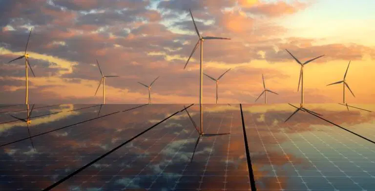
Forecasting Services for RES
Specialized weather forecasts for the operational needs of RES: wind forecast at various wind turbine operating heights, solar radiation forecast for photovoltaic parks. Design and implementation of a web application for reviewing results and supporting planning and decisions.
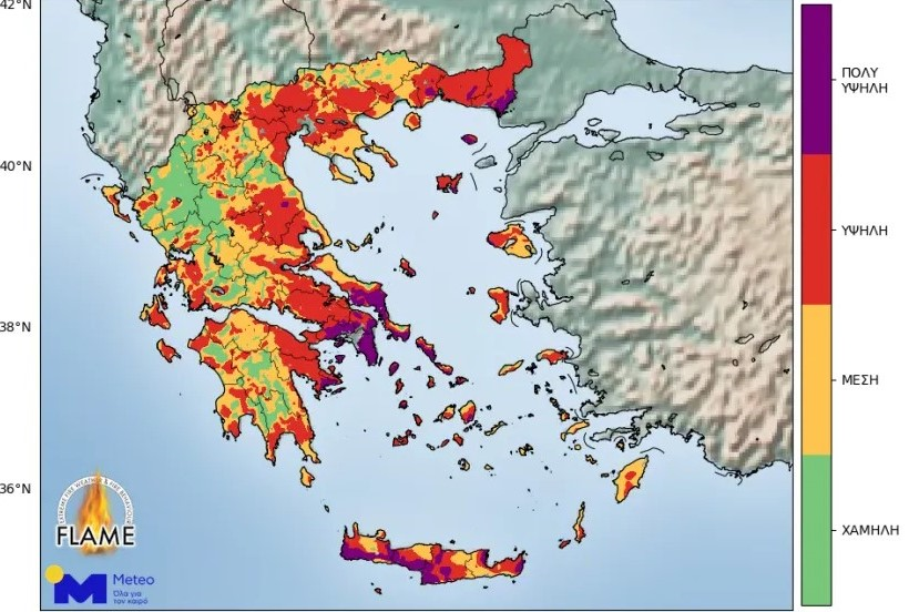
Pyrometeorological Forecasts and Observations
Provision of specialized forecasts and data regarding pyrometeorological risk in Greece. Includes three-day risk forecasts, real-time data from IERSD stations, and medium-term assessments of pyrometeorological risk at a regional level.
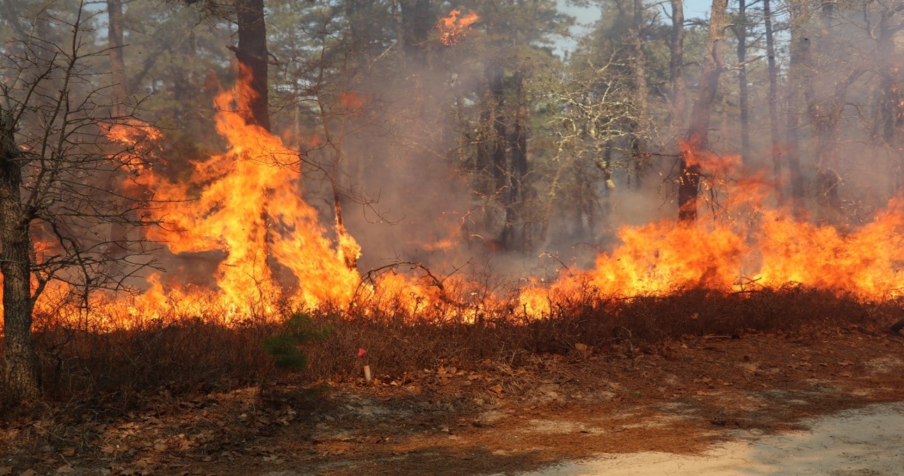
Fire Forecasting and Analysis
Provision of near real-time fire spread forecasts through an advanced numerical model. The service includes retrospective analysis of incidents to draw lessons and utilization of satellite data for mapping and studying fire behavior.
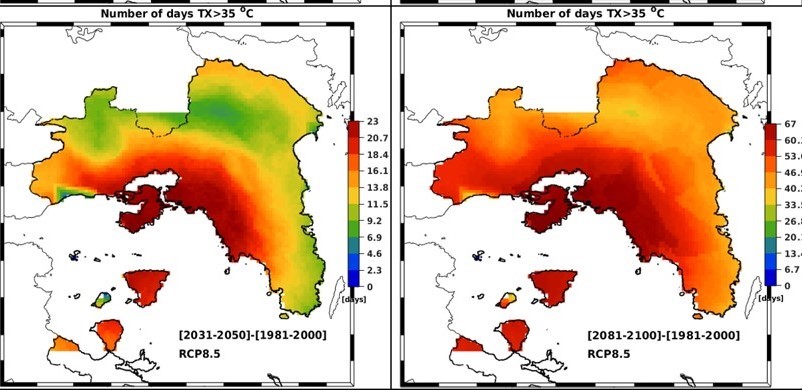
Long-term Climate Projections
Projections of mean values of climatic parameters and extreme weather events up to 2100 at high spatial resolution, in the form of maps and/or data files, using various regional climate models and climate change scenarios.
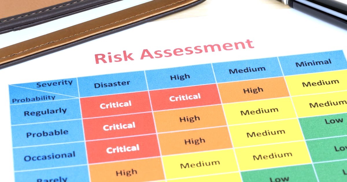
Climate Change Risk Assessments
Indicators of climate change impacts in various sectors (e.g., agriculture, health, tourism, forest fires) at high spatial resolution, and integrated risk analyses for various economic activities, businesses, and investments.
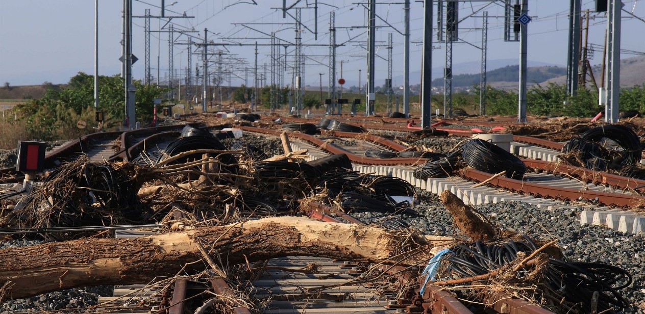
Infrastructure Risk and Vulnerability Analysis
Provision of services for vulnerability analysis of critical infrastructure to climate risks in the present and future climate. Design and implementation of a web application for reviewing results and supporting planning and decisions.
Carbon and Environmental Footprint
Estimation of Scope 1, Scope 2, and Scope 3 greenhouse gas emissions per activity, service, or production level, applying internationally recognized methodologies, and evaluation of reduction measures. Extension of estimations for air pollutants and biodiversity.
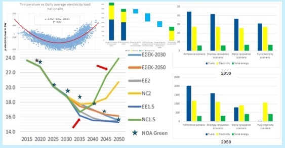
Energy Forecasts
Forecasting of energy and power demand with the integration of economic and meteorological parameters, forecasting of electricity generation from conventional power plants and renewable energy sources, development and evaluation of ‘green’ energy transition scenarios.

Energy Efficiency and Sustainability in the Built Environment
Energy simulations of buildings, assessment of thermal comfort and indoor environmental quality, and proposals for energy upgrades. Calculation of the carbon footprint of buildings with life cycle analysis. Evaluation of buildings-neighborhoods-cities-regions with sustainability indicators. Study and prioritization of scenarios for energy upgrading of the building stock to achieve medium- and long-term targets for reducing emissions from the building sector.
Energy Planning and Management of Renewable Energy Sources
Holistic approach to remote monitoring and forecasting of distributed electricity generation from photovoltaic systems using geo-observation methods. Development of business plans for solar system exploitation, climatological maps in the form of a renewable energy atlas, smart grids, management systems for the transmission and distribution of energy generated from renewable sources at local (smart cities) and regional scales (countries, cross-border applications), autonomous energy islands, support for energy transition and security decision-making.