Meteorology and Hydrology
Extreme weather and hydrometeorological phenomena, water resource availability, and forest fires pose an increasing threat to society, the environment, and the economy. As climate change intensifies the frequency and intensity of extreme events, the need for continuous monitoring, accurate forecasts, and timely warnings is more pressing than ever. To address this challenge, we focus our research efforts on developing and implementing innovative methodologies and tools for more effective monitoring, understanding, and forecasting of phenomena such as heatwaves, droughts, extreme rainfall, floods, reduced availability of surface and groundwater resources, and forest fires.
Research Challenges
Weather Monitoring and Forecasting
- In a world where extreme hydrometeorological phenomena are occurring with increasing frequency and intensity, we face a series of critical research challenges. The first and fundamental challenge is to improve our understanding of hydrometeorological phenomena so that, through the development of advanced observation systems and the improvement of forecasting models, we can achieve more accurate forecasts of dangerous weather events.
- In alignment with the UN’s Early Warning for All initiative, we are called upon to address the challenge of creating effective early warning systems that reach every citizen, ensuring universal protection from the impacts of dangerous hydrometeorological phenomena.
- An equally important challenge is understanding and quantifying the social impacts of these phenomena, a process that requires innovative methodologies and an interdisciplinary approach. In the field of forest fires, understanding the complex interactions between fires and the atmosphere remains one of the greatest challenges of our time.
Atmospheric Remote Sensing and Meteorological Applications
- Forecasting heavy rainfall in coastal areas with complex topography that significantly affects precipitation, such as in the Mediterranean region. Meteorological models lack the required accuracy in such cases, especially in flash flood forecasting, thus requiring alternative forecasting methodologies.
- Development of a flood early warning system with detection, monitoring, analysis, and risk forecasting. Remote sensing techniques, primarily meteorological radars, but also satellite meteorological measurements, tropospheric products from ground-based GNSS (Global Navigation Satellite System) stations, and lightning detection networks, are key elements for achieving more accurate weather forecasting through real-time data analysis and assimilation into high-resolution meteorological forecasting models.
Hydrology – Water Resources
- In conjunction with UN Sustainable Development Goals No. 6 and 13, the disruption of the hydrological cycle due to both the global increase in atmospheric temperature and changes in land use, presents significant impacts on extreme hydrometeorological and hydroclimatic phenomena, creating new challenges in their understanding, forecasting, and management.
- The collection of high-quality hydro-environmental information is essential for water resource management, as well as for assessing hydrological risks. Furthermore, the sustainable management of underground coastal aquifers under conditions of climate change and increasing anthropogenic pressures (e.g., reduced precipitation, sea-level rise, water pumping, water recycling) must be addressed as a priority and in light of socio-economic data.
The research activities of IERSD focus on these scientific challenges, combining data collection and utilization, development of analytical methodologies, models, and tools, field research, and meaningful communication with decision-makers and citizens.
The goal of IERSD is for the results of research in Meteorology and Hydrology to reach society, serving the collective well-being.
Key Research Areas
Ground and satellite weather observation
- Operation, analysis, and quality control of data from a network of approximately 580 meteorological stations.
- Analysis of extreme values and return periods.
- Satellite remote sensing of meteorological phenomena and analysis of their dynamics, utilizing EUMETSAT’s SAF tools, development of nowcasting methods.
- Utilization of all observation networks to provide specialized services.
Contact:
Vassiliki Kotroni (kotroni@noa.gr)
Weather, wave, and desert dust transport forecasting
- Production of high-resolution short-term weather forecasts using regional meteorological models. Verification and optimization of their operation.
- Development of algorithms for lightning activity/hail forecasting. Production of desert dust transport forecasts.
- Analysis of seasonal weather forecasts and assessment of their impacts on the economy.
- Utilization of all forecasting products to provide specialized services in civil protection, agriculture, energy, and tourism sectors.
Contact:
Vassiliki Kotroni (kotroni@noa.gr)
Kostis Lagouvardos (lagouvar@noa.gr)
Analysis of extreme weather phenomena
- Combined use of all observational and forecasting products for a better understanding and analysis of the dynamics and microphysics of extreme phenomena (e.g., Mediterranean lows and cyclones, heavy snowfalls).
- Study of extreme temperatures and thermal stress on health, development and adaptation of biometeorological indices.
Contact:
Kostis Lagouvardos (lagouvar@noa.gr)
Theodoros Giannaros (thgian@noa.gr)
Development and applications of meteorological radar-remote sensing
- Studies of clouds and rainfall, and flood forecasting, with real-time recording, via meteorological radars, of the spatial distribution of atmospheric precipitation.
- Algorithms for calculating rain microphysics products from meteorological radar data. Techniques for assimilating radar data, humidity from GNSS measurements, and spatial distribution of lightning into meteorological forecasting models for short-term (up to 3 hours) rainfall forecasting, and its integration into hydrological models for flash flood forecasting (especially in urban areas).
- Climatological studies of rainfall in the Mediterranean through satellite data analysis, with emphasis on the frequency and intensity of extreme rainfall.
Contact:
Ioannis Kalogiros (jkalog@noa.gr)
Air-sea interaction with emphasis on turbulent processes
- Improving the understanding of physical processes, parameterizations of turbulent flow, and the propagation of electromagnetic and optical waves near the sea and land surface.
- Experimental campaigns, in collaboration with US agencies, for the analysis of data from various measurement platforms (ships, aircraft, buoys, meteorological masts, sodars), and modeling studies (Large Eddy Simulations) of the Atmospheric Boundary Layer.
Contact:
Ioannis Kalogiros (jkalog@noa.gr)
Analysis and utilization of satellite and climatic rainfall data
- Comparison of satellite rainfall data with ground measurements (rain gauges) or other reliable sources (radar, re-analysis data).
- Analysis of satellite rainfall estimates from available databases for the study and monitoring of extreme phenomena, and assimilation of these data into numerical weather prediction models.
- Evaluation of algorithms for converting radiation received by satellite receivers into rainfall rate.
- Investigation of changes in the frequency of extreme rainfall and/or drought events through analysis of climatic rainfall data (on an hourly/daily/monthly basis) from databases.
- Evaluation of climatic rainfall data from available databases with progressively increasing spatial resolution.
Contact:
Adrianos Retalis (adrianr@noa.gr)
Dimitrios Katsanos (katsanos@noa.gr)
Climate Change
- Analysis of trends in key meteorological parameters in the present and future climate using a combined approach of reanalysis data for the current climate, meteorological records, and future climate scenarios.
- Analysis of changes in intensity/frequency/duration of high temperatures, precipitation, and snow cover in the Greek mountains.
Contact:
Kostis Lagouvardos (lagouvar@noa.gr)
Educational Meteorology
- Design, development, and operation of specialized educational programs for students on topics of weather, climate, weather phenomena, and protection from them.
- Design and development of online educational material. Analysis of literacy in meteorology.
Contact:
Ioannis Koletsis (koletsis@noa.gr)
Vassiliki Kotroni (kotroni@noa.gr)
Study of social and economic impacts
- Recording, monitoring, and analysis of socio-economic impacts of intense and extreme weather phenomena.
- Conducting and analyzing behavioral surveys on risk perceptions, preparedness, adaptability, and response to hydrometeorological and climatic hazards.
Contact:
Katerina Papagiannaki (katpap@noa.gr)
Vassiliki Kotroni (kotroni@noa.gr)
Radiometric observations
- Development and operation of ground-based networks of automatic radiometric stations for recording the intensity of incoming solar radiation (global, direct, diffuse) and/or its components (e.g., natural illumination, photosynthetically active radiation, ultraviolet radiation).
- Estimation of available solar energy levels during the study phase of PV system installation.
Contact:
Vasilis Psiloglou (bill@noa.gr)
Pyrometeorology
- Development and operation of ground-based measurement networks for real-time monitoring of pyrometeorological risk.
- Forecasting fire spread and studying their interactions with the atmosphere through advanced models.
Contact:
Theodoros Giannaros (thgian@noa.gr)
Study of the hydrological cycle
- Analysis of changes in the hydrological cycle, with an emphasis on the interconnection of climate change and extreme hydrological phenomena.
- Assessment of the impacts of hydrological cycle disruption on water availability across multiple spatio-temporal scales and environments, using machine learning methods, stochastic analysis, and numerical models.
Contact:
Ioannis Markonis (markonis@fzp.czu.cz)
Surface Hydrology
- Development of the hydro-telemetric network and construction of stage-discharge curves.
- Flood estimation at various scales in urban and natural catchments and flood risk assessment, initially in catchments monitored by the hydro-telemetric network.
- Hydrological and hydraulic modeling of catchments as a tool for flood early warning and water resource management.
Contact:
Aikaterini Mazi (kmazi@noa.gr)
Evangelos Rozos (erozos@noa.gr)
Groundwater Hydrology
- Analysis of the impacts of loads (climate-human) on aquifer dynamics (and stochastically), focusing on seawater intrusion in coastal aquifers.
- Sustainable water management in Mediterranean islands/regions with deficit balances and high demands, considering water reuse and desalination of brackish groundwater.
- Investigation of the dependence of coastal wetland ecosystem function on groundwater dynamics.
Contact:
Aikaterini Mazi (kmazi@noa.gr)
Evangelos Rozos (erozos@noa.gr)
Achievements – Distinctions of Team Members
The Pillar members have a significant international presence and important roles in international committees, as exemplified below:
![]() Main creators of the open database FFEM-DB (Database of Flood Fatalities from the Euro-Mediterranean region) and its publication in the journal Scientific Data of Nature, and collaboration with the Risk Data Hub of the European Commission’s Joint Research Centre.
Main creators of the open database FFEM-DB (Database of Flood Fatalities from the Euro-Mediterranean region) and its publication in the journal Scientific Data of Nature, and collaboration with the Risk Data Hub of the European Commission’s Joint Research Centre.
![]() Participation, following appointment by the European Space Agency (ESA), in the Mission Advisory Group of the new Hydroterra+ space mission for Earth observation. This specific space mission is one of 4 missions selected by ESA to proceed to the next stage of feasibility study.
Participation, following appointment by the European Space Agency (ESA), in the Mission Advisory Group of the new Hydroterra+ space mission for Earth observation. This specific space mission is one of 4 missions selected by ESA to proceed to the next stage of feasibility study.
![]() Creators of the Meteorology educational program “About Winds & Waters” of the National Observatory of Athens for Secondary Education students, which was awarded the Greek Green Award 2022 in the category “Environmental Educational Program in schools” at the 4th International Exhibition Verde-tec.
Creators of the Meteorology educational program “About Winds & Waters” of the National Observatory of Athens for Secondary Education students, which was awarded the Greek Green Award 2022 in the category “Environmental Educational Program in schools” at the 4th International Exhibition Verde-tec.
![]() Representation of NOA in the National Risk Assessment Committee of the Ministry of Climate Crisis and Civil Protection.
Representation of NOA in the National Risk Assessment Committee of the Ministry of Climate Crisis and Civil Protection.
![]() Main creators of the website www.meteo.gr, the most popular weather website in Greece with an average of >300,000 visitors daily.
Main creators of the website www.meteo.gr, the most popular weather website in Greece with an average of >300,000 visitors daily.
![]() Development and operation of the HYDRONET hydro-telemetric network in rivers and streams of Attica and Peloponnese.
Development and operation of the HYDRONET hydro-telemetric network in rivers and streams of Attica and Peloponnese.
![]() Environmental Sensitivity Award ‘OIKOPOLIS’ (in 2018) from the ECOCITY Volunteer Organization in the category ‘SCIENTIFIC LABORATORY or TEAM’, for its contribution to the study of climatic and atmospheric changes, through the preservation and promotion of a historical climate archive spanning more than a century and a half.
Environmental Sensitivity Award ‘OIKOPOLIS’ (in 2018) from the ECOCITY Volunteer Organization in the category ‘SCIENTIFIC LABORATORY or TEAM’, for its contribution to the study of climatic and atmospheric changes, through the preservation and promotion of a historical climate archive spanning more than a century and a half.
![]() Development and operation of the densest network of meteorological stations in Greece. The network’s development began in 2006 with the installation of the first station in Chania and reached 580 stations by December 2024.
Development and operation of the densest network of meteorological stations in Greece. The network’s development began in 2006 with the installation of the first station in Chania and reached 580 stations by December 2024.
![]() Certificate of Recognition of the NOA Historical Climate Station by the World Meteorological Organization (WMO) “NATIONAL OBSERVATORY OF ATHENS RECOGNIZED AS A LONG-TERM OBSERVING STATION BY THE WORLD METEOROLOGICAL ORGANIZATION IN MAY 2017 FOR MORE THAN 100 YEARS OF METEOROLOGICAL OBSERVATIONS”. The station was among the 60 officially recognized century-old stations worldwide.
Certificate of Recognition of the NOA Historical Climate Station by the World Meteorological Organization (WMO) “NATIONAL OBSERVATORY OF ATHENS RECOGNIZED AS A LONG-TERM OBSERVING STATION BY THE WORLD METEOROLOGICAL ORGANIZATION IN MAY 2017 FOR MORE THAN 100 YEARS OF METEOROLOGICAL OBSERVATIONS”. The station was among the 60 officially recognized century-old stations worldwide.
Representative projects
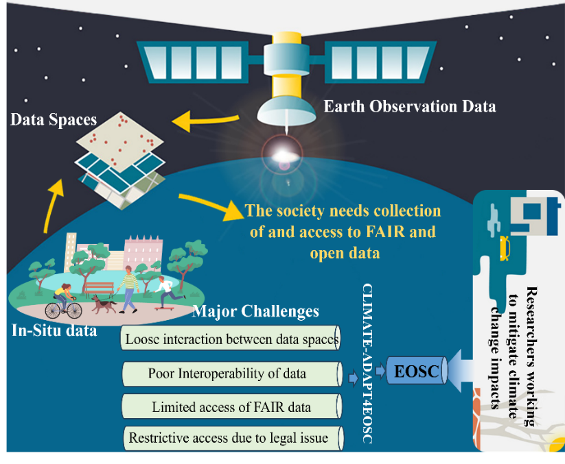
CLIMATE-ADAPT4EOSC (Advancing climate adaptation through open science and data integration in the European Open Science Cloud)
The CLIMATE-ADAPT4EOSC project aims to remove existing barriers to accessing and integrating climate data, fostering a collaborative research environment where data can flow seamlessly between stakeholders. The ultimate goal is to contribute to the field of climate change adaptation.
Duration: 01/2025 – 12/2028
Funding: Horizon Europe
Contact: Vassiliki Kotroni (kotroni@noa.gr)
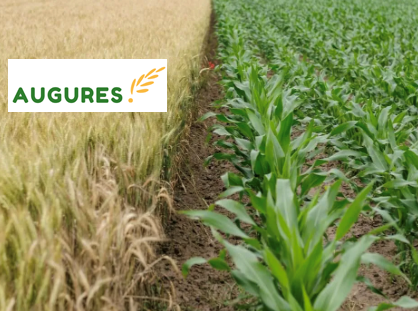
AUGURES (Strategic service to translate complex planet-level messaging about climate emergency into a personal understanding of the impacts amongst key stakeholders)
The project uses an innovative interdisciplinary methodology to assess the impacts of climate change on crop yields, agricultural income, and food security, providing action-oriented information for local and international stakeholders. Emphasis is placed on seasonal forecasting and forecasting for the next decade.
Duration: 12/2023 – 12/2025
Funding: European Climate Foundation
Contact: Kostis Lagouvardos (lagouvar@noa.gr)
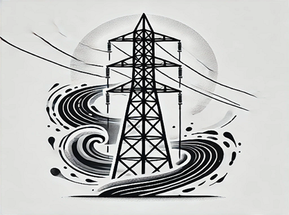
Analysis of climate vulnerability of HEDNO infrastructure
The project aims to analyze the vulnerability and risk of HEDNO infrastructure per regional unit of the country for existing and future climate conditions. The risks analyzed are: high temperatures, low temperatures, heavy rainfall, floods, gale-force winds, forest fires.
Duration: 06/2024 – 04/2025
Funding: Hellenic Electricity Distribution Network Operator (HEDNO)
Contact: Kostis Lagouvardos (lagouvar@noa.gr)
Development of weather monitoring & early warning systems
The project aims to develop weather monitoring & early warning systems adapted to the needs of sectoral services such as highway network management (NEA ODOS, KENTRIKI ODOS), marine projects (Aegina Subsea Pipeline), etc.
Duration: 11/2020 – 10/2026
Funding: Private Sector
Contact: Kostis Lagouvardos (lagouvar@noa.gr)
Design of a National Strategy for the Adaptation of Cultural Heritage Monuments Protection to the Impacts of Climate Change
The project seeks to contribute to the national effort to address climate risks and the impacts of climate change on culture, by creating guidelines and best practices for infrastructure and actions that support climate change adaptation. It aims to identify and record the impacts of climate change on cultural heritage monuments and to spatio-temporally define the four-part framework of “exposure-sensitivity-adaptive capacity-vulnerability.”
Duration: 05/2023 – 05/2026
Funding: Ministry of Culture
Contact: Vassiliki Kotroni (kotroni@noa.gr)
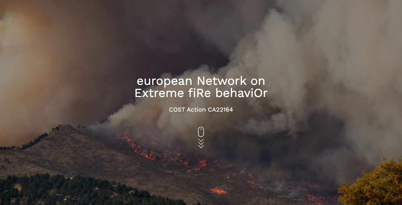
NERO (european Network on Extreme fiRe behaviOr)
The NERO Action network connects researchers and professionals to deepen the understanding of extreme wildfires. A key objective is to enhance preparedness and resilience through the utilization of new scientific knowledge in practical tools.
Duration: 10/2023 – 10/2027 `
Funding: COST Association
Contact: Theodoros Giannaros (thgian@noa.gr)
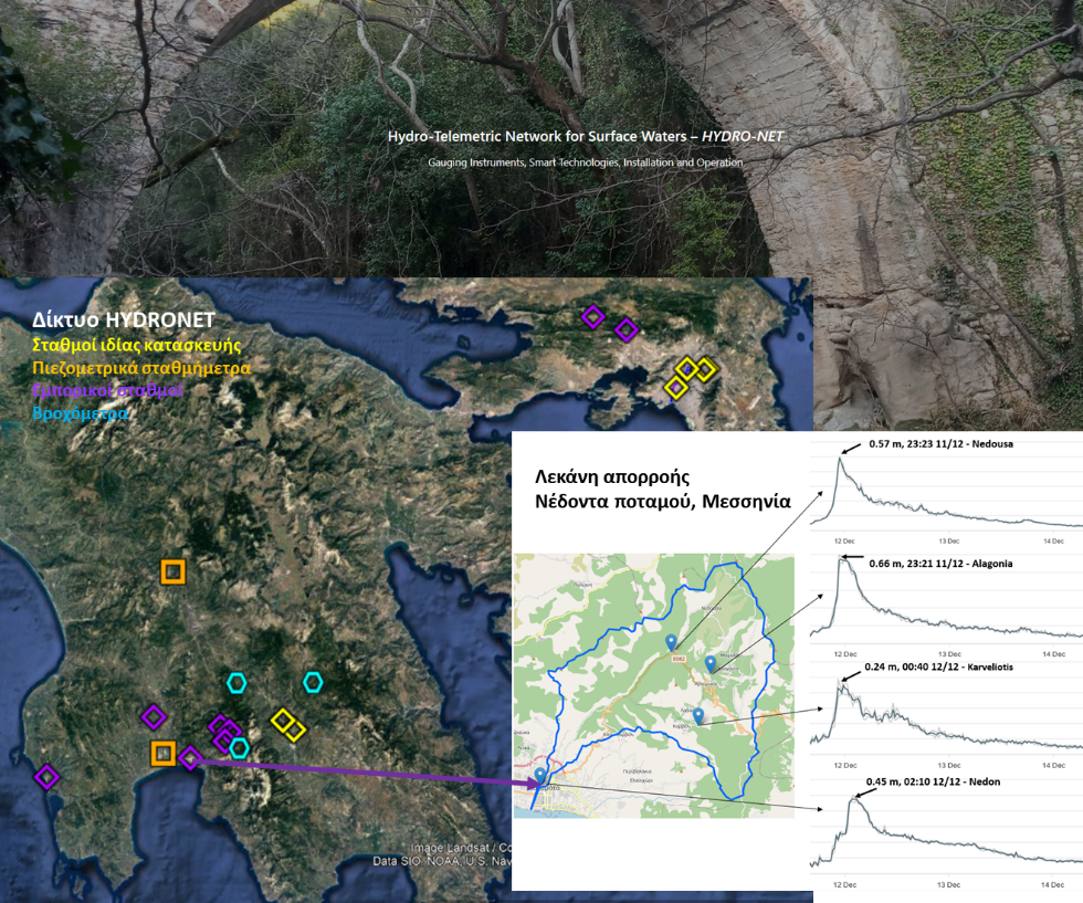
HYDRO-NET Hydro-Telemetric Networks for Surface Waters: instrumentation, smart technologies, installation and operation)
HYDRO-NET was a sub-project of the HIMIOFoTS Action with the main objective of installing and operating a prototype hydro-telemetric network for monitoring surface waters, with the prospect that the design principles and optimal operation of this network would be applied to the hydrometric networks of the Greek Territory. The main goal was to collect high-quality hydro-environmental information and make the data available through the OpenHi.net network (Open Hydrosystems Information platform). A significant innovation was the design and construction of modern telemetric level-measuring stations, at half the cost of comparable commercial ones, and their installation in the network.
Duration: 01/2018 – 11/2021
Funding: O.P. "Competitiveness, Entrepreneurship and Innovation"
Contact: Katerina Mazi (kmazi@noa.gr)
Research Team
No staff members found in this category.